
 Saddell History
| Place Name | Grid Ref. |
|---|---|
| A'Chruach The heap, pile; peat?stack or hay?stack | NR762318 |
| Allt Criche The Boundary stream | NR797344 |
| Allt na Beiste The stream of the beast | NR783292 |
| AIlt na Gamhnaich (Gavnach) The stirks' stream | NR773335 |
| Allt na Teangaidh Moire The stream of the big tongue | NR775315 |
| Allt nam Manach The monks' stream | NR788321 |
| Allt Thormaid Tormod's stream (N. "Thorr + mudr"?Thorr's wrath) | NR775332 |
| An Struthlag (Strulag) The small stream | NR800326 |
| Bealach na' Marbh The pass of the dead | NR786322 |
| Beinn an Tuirc The mountain of the boar | NR752362 |
| Bord Mór The big table (plateau) | NR753339 |
| Braid Hill The gully hill | NR737340 |
| Bunlarie (Bun lárach) The foot of the ruin | NR785307 |
| Cnoc a' Mhadaidh (Crockavaddy) The hill of the dog | NR764345 |
| Cnoc na Caillich The hill of the old woman | NR779342 |
| Cnocan a'Bhuachaill The shepherd's hill | NR795328 |
| Creag an Fhithich (Craiganfeach) The raven's crag | NR763353 |
| Creag Creamha The crows' crag | � |
| Creag Thormaid (Craigcórmad) Tormod's cliff | NR775328 |
| Creagan Rainich The bracken hill | NR789347 |
| Crockineach (Cnoc na riabhach) The hill of the brindled field (now the farm of Lephinmore) | NR786326 |
| Cuil na Sithe (Cul na Shee) The peaceful nook; fairy dell A Landmark Trust property | NR789312 |
| Greenhill Now a craft shop | NR795346 |
| Guesdale Water (N. Gas + dal) The goose valley | NR768338 |
| Home Farm (formerly The Kennels) | NR786323 |
| Ifferdale (N. yfir + dal) The upper valley | NR771339 |
| Lephincorrach (Leth?pheighinn corrach) The steep halfpenny land | NR789359 |
| Lephinmore (Leth?pheighinn m6r) The big halfpenny land | NR785326 |
| Miller's Park The field behind Saddell village. The ruins of the mill are across the main road from the village | NR785322 |
| Pluck Point Possibly the point where small herring were "plucked" from nets | NR798317 |
| Pluck Wood (G. pluc) Possibly sheep?rot wood | NR798320 |
| Port na Cuthaig (Portnacook) The port of the cuckoo | NR790312 |
| Port na Gael The port of the Gael | NR795318 |
| Port nan Gall The port of the strangers (or lowlanders) | NR799318 |
| Rubha nan Sgarbh (Roo'a?nan?skarv, N. Skarfr) The point of the cormorants (locally "scarts") | NR800340 |
| Saddell (N. sandr + dal) Sandy valley | NR785322 |
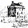
| Saddell Castle A Landmark Trust property | NR785315 |
| Saddell House A private house, built in 1774 | NR791318 |
| Saddell Lodge House occupied by a caretaker for The Landmark Trust | NR786320 |
| Shore Cottage A Landmark Trust property | NR789314 |
| Teangadh Mhór The big tongue (of land between two ravines) | NR778320 |
| Torrisdale Thorr's valley | NR793362 |
| Ugadale (N. ugla + dal) The valley of the owl | NR780287 |
| Whitestone probably translation of G. "carraig bhan" | NR794339 |
| Whitestone Dun Iron Age fortlet dating from 20OBC- 200AD | NR797340 |
From:
Saddell - A Guide for
Visitors,
By Norman S. Newton,
1988, Michael Press, Glasgow.
You can find an explanation to the Ordnance Survey Grid at their web page. The National Grid.
"Place names
These names have been taken from modern Ordnance Survey maps (1:10000 and 1:50000), from the OS "County" maps surveyed in the 1860s and republished with corrections in the 1920s (1:10560), and from a manuscript map of Saddell Estate in 1784.
Wherever possible, the Gaelic (G) or Norse (N) meaning has been supplied: these derivations are sometimes rather dubious, especially where the spelling of a name has been corrupted, and further suggestions would be most welcome! With difficult Gaelic names, an attempt has been made to indicate the correct pronunciation.
This list represents only a fraction of the place-names which once existed and are now, regrettably, lost. At one time every field, rock and rivulet would have had its own Gaelic name.
National Grid References (NGR) have been supplied: all
should be prefixed with the letters NR. In the case of rivers
and streams, the NGRindicates where the stream joins the sea,
or a larger river."
The Author
