|
"During the dark ages, Scotland, like the rest of Britain, was a melting pot for the roving peoples of northern Europe. Angles, Britons, Picts and Scots occupied different parts of the country, and had little in common except newly learnt Christianity and terror of the Norse raiders. It was this shared fear which finally brought Picts and Scots to unite under a single king, Kenneth MacAlpin, in AD 844." "By 1561, much of the country was under the sway of the Protestant Kirk, and the aristocracy, including Mary Queen of Scots new husband Lord Darnley, equaled their treachery to the queen only by their treachery to one another. In 1567, Mary was forced to abdicate and she later fled to England, seeking the help of Elizabeth I. Elizabeth had none to offer; instead, she imprisoned Mary for 19 years, and finally executed her." "In 1707, despite the protests of most of the people, the Scottish Parliament signed away its separate existence in exchange for religious tolerance, free trade with England, and heavy bribes. Dissatisfaction with the Union, and a wish to choose their own destiny, rallied Highlanders to the Stuart cause in 1715 and 1745. But these hopes were finally crushed by the English at Culloden on April 16, 1746, and Scottish independence had to exist only in men's minds until recent moves towards devolution."1
Scottish Lowlands"Traditionally, the southern half of Scotland is known as the Lowlands - a description which suggests flatness and a certain lack of variety. But the Lowlands, though not challenging the grandeur of the rugged North West Highlands, are more hilly than most parts of England, and the climate, particularly in the central areas, can be as harsh in midwinter as that endured by any lonely hamlet in the Highland mountains. The dour and determined people of the Lowlands are typical of the Scots as the world tends to think of them, and the history of the Borderland between England and Scotland has been even more turbulent than that of the remote Highlands." "Southern Scotland's most settled weather is between March and June. July tends to be cloudy and, in the west, August is generally wetter than in most other parts of Britain. The Firth of Forth, however, is a notably dry area - Inchkeith Island has 22 inches of rain a year, compared with Edinburgh's 24 - 27 inches, Greenock's 62.5 and an average for the whole of Scotland of 50 inches. Ayrshire's west coast, protected by hills, has an excellent sunshine record."2 "The two major cities of the Lowlands are Glasgow and Edinburgh - less than 50 miles apart in terms of travel, but a world apart in terms of their industry and architecture. Edinburgh is one of Europe's most beautiful capitals. It is built upon hills in a superb natural setting, over-looked by a mountain in miniature, Arthur's Seat, and with a 1000 year old castle at its center. In the 18th century, Edinburgh was the home of philosophers and wits, poets and scientists. They helped to bring a cosmopolitan atmosphere to the city that is still sustained each year by the Edinburgh International Festival of music and drama. Superb lonely countryside is within easy reach of the capital, south west, the 16 mile long Pentland Hills, which Robert Louis Stevenson loved; south east the lonelier Moorfoot Hills." "Glasgow, with its satellite towns, forms the huge industrial heart of the Lowlands. It grew from being a pleasant burgh in pretty countryside into a great city - starting first in the 17th century as a major seaport to which sugar and tobacco were imported from America, then completing its development in the last 150 years with the establishment of steel works and large docks and shipyards along the River Clyde. Today, Glasgow is Scotland's largest city and is the third largest in population in the British Isles."3 "Biographies of Scots often begin with the story of a poor boy trudging to university carrying a sack of oatmeal which had to last him the entire year. Poverty, and the careful husbandry of meager resources in a rigorous climate, have done much to shape the Scottish character. Presbyterian doctrine, with its emphasis on man's responsibility to God, had a particular appeal to the self-reliant people of the Lowlands." "Accents change within a few miles of crossing the English frontier, and so do attitudes. Ruined forts, the relics of old frontier wars, stud the landscape on both sides of the Border, yet the Scots are more aware of the history and legends surrounding them than are the English. Statues on war memorials are depicted as wearing the bonnets of Scottish regiments, and the architecture of older buildings has little in common with English traditions. Often, as in Edinburgh's Old Town, the buildings show evidence of longer, closer contacts with the Continent of Europe than with southern Britain. The farmlands of Central Lowlands are rich, but they are not like England's. There are fewer hedges, more walls, and often on the horizon there are mountains."4 It was in these Scottish Lowlands that the Ralston families find their roots. First in the Ayreshire region south-west of Glasgow. Later years found Ralston's in The Highlands on the Kintyre Peninsula to the south-west across the Firth of Clyde and Kilbrannan Sound, a distance of about sixty air miles.
RALSTON Estates, Renfrewshire"The ancient barony of Ralston in Renfrewshire consisted of Auldtown, Hullhead, Barshaw, Whitehaugh, Byres, Honeybog, Pennylee, Maylee, Auldhall and Ralston-Wood. These properties were sold by Gavin Ralston of that Ilk in 1704 to John, Earl of Dundonald, who conferred them on his daughter, Lady Anne Cochrane, when she married James, the fifth Duke of Hamilton. Their son sold Ralston in 1755 to William MacDowal of Castle-Semple, an eminent Glasgow merchant and one of the founders of the Ship Bank there. His son, William of Garthland and Castle-Semple, sold Ralston in 1800 to William Orr, son of a Paisley manufacturer who with his brother had made a fortune in the manufacture of linens in Ireland where they had introduced and brought to perfection the art of printing linens. Three years earlier he had acquired from the Earl of Glasgow, part of the lands of Ingliston, on which he built an elegant manor house. Upon his purchase of Ralston he merged all of his estate into one which he called Ralston and the house became the Mansion of Ralston. In 1840 James Richardson, a Glasgow merchant, secured it. His son, Thomas, enlarged the mansion and increased the size of the estate. "Today there is an area called Ralston on the east side of Paisley." As you drive east on A737 toward Glasgow, you will pass through it. The Ralston Golf Club is located just south of the highway east of Paisley. It once was part of Ralston estates. "William Patrick of Roughwood, the grandson of Jean Ralston, aunt of the last Ralston of that Ilk, purchased the property in 1833. After sixty-two years Woodside-Ralston was back in the hands of a family member. Upon William's death his nephew, Robert William Cochran Patrick, a member of Parliament for North Ayrshire, was heir. It seems to be through Mr. Patrick's interest in his maternal lineage that much of the information of this family is available. "Woodside-Ralston and Auchingown near Beith in Ayrshire were sold by the last Gavin Ralston of that Ilk in 1771 to Dame Jean Stirling of Auchyle, wife of the Honorable James Erskin of Alva, Lord Barjoy of Session and later one of the Senators of the College of Justice under the title Lord Alva. The residence served as their summer home until their death at which time her cousin, General Alexander Graham Stirling of Duchrae and Auchyle was heir." "It may have been in the 1880's that the estate was once more lost to the family. We visited there in 1982 to find the building in good condition and occupied by a retired army officer and his family." Woodside is located just outside Beith, past the cemetery to the north-west on King's Road.5
The HIGHLANDS and the KINTYRE Peninsula"To the west of Ayrshire, across the Firth of Clyde and Kilbrannan Sound, lies the peninsula of Kintyre in the extreme southern reaches of the Highland Argyllshire." "If it were possible to reconstruct accurately an aerial photograph of a cluster of Kintyre farms, any farms, so that they appeared as they had been in say, the late seventeenth century, (when Ralston's first arrived), it is unlikely that many would be recognizable. The buildings would bear no resemblance to present-day farm buildings, and there might be so many of them that one would imagine a village had been there; the land would be almost entirely open, with scarcely a fence of any description to be seen; much of it might lie under water or be noticeably boggy. Even the ploughed fields and the tiny grazing farms of sheep and cattle would have an odd appearance. The system of farming then was runrig. (The joint-farm was worked as a whole by the subtenants who were each allocated parts of it. There were three essential elements to the system: the dwelling, arable, and common pasture. The clustered houses were surrounded by, or stood adjacent to an area of 'infield' land, beyond which lay the detached portions of 'outfield'. Each individual held strips- or rigs- of land of varying quality, scattered here and there in both infield and outfield.) All that began to change in the early eighteenth century, but the change came slowly, and not until the middle of the nineteenth century would the face of the land have assumed the features by which it is recognizable today. But more than a system of farming changed - a people's lifestyle also changed. These pressures of change may be seen at their most extreme where the principles of market farming swept away communities basically geared to subsistence farming (for example, around the Mull of Kintyre, which was stocked with sheep towards the end of the eighteenth century)." "The joint-farm was a large unit, usually possessed by a tacksman. He generally held the 'tack', or lease, by virtue of his kinship with the chief of some special status. In Kintyre, the division -and abolition- of the big runrig farms began about the middle of the eighteenth century, and was followed by subdivision which continued into the early nineteenth century (to be countered, ironically, by an amalgamation trend which continues unimpeded to this day). Thus, for example, in 1792 Glenagervy was subdivided into four parts: High, West, South Shore and North-west Shore. Rev. John Smith remarked particularly on the effects of subdivision in Southend: "in no part of the county are possessions more uniformly moderate ... In consequence of this, more waste ground has been of late years improved in this parish than in any other in the county. The yellow corn now waves on the region lately occupied by the heath and moss." "The biggest of these was at Machrimore, which retains even today the appearance of a small village, having thirteen occupied houses clustered at the derelict mill. In 1779, on Machrimore Farm, the adult male population comprised three tenants, the son of a tenant, six servants, and two cottars, constituting -together with the unrecorded women and children- five families. At the mill itself, sixteen families lived. There was one tenant, the miller himself, and fifteen cottars, most of whom must have been tradesmen or laborers. In 1842, there were twenty-one occupied houses at the mill and on the adjacent farm. The population of 116 included four tenant-farmers, four weavers, two tailors, two shoemakers, a cartwright, smith, and miller and schoolmaster, along with farm-laborers." "Throughout the nineteenth century the population of rural Kintyre - farmers, cottars, laborers and tradesmen- ebbed away. the evidence is bared in statistics. Between 1831 and 1881, the population of Southend dropped from 2120 to 995. There was a steady movement into Campbeltown for work in distilleries, trades, and at laboring and fishing, but the greatest movement was overseas, to Canada, the United States, Australia and elsewhere."6 The Kintyre lands had come into the possession of the Campbell's over a period of a century from the early 1500's, many from the grants made by the King to compensate the family for the suppression of disorder. It was not until 1647 that Archibald Campbell, the 8th Earl of Argyll, defeated the Macdonalds, his old and bitter enemies. The Earl of Argyll was a staunch supporter of the Covenanters and vigorously opposed to the imposition of Episcopacy. Charles I recognized his great influence and in 1641 made him the 1st Marquis of Argyll. Argyll led an army of Covenanters in 1642 to quell a rebellion in North Ireland. In 1644 - 45 he led many of the same troops against the English royalist, Montrose, who defeated Argyll repeatedly. In the final drive for control of Kintyre and the nearby islands in 1647, much of the male population was decimated. In the same year an epidemic of plague engulfed the area. wiping out whole families." "In these unsettled times the shrewd Marquis knew he must strengthen his hand for the future. As head of the Covenanters, he turned to those men for help. To colonize Covenanters into Kintyre would once more create income from rents and assure him of a faithful population to serve him militarily as necessary. He chose William Ralston of that Ilk as leader in what has become known as the Plantation of the Lowland Lairds." "The design of the Plantation was intended to secure for the Marquis a strong political and, if necessary, military backing in the district, and at the same time to introduce peaceable and thrifty tenants, who would enable him to recover the value of his estates which had been wasted by war, transportation and plague. The new tack holders, (lease holders), whose main activities were absorbed in the political and military doings of the times, and as the tacks were of holdings much larger than a single man could work, the tacksmen who were responsible for the rents, brought along with them many of their relations, with whom they shared the holdings, but of whom, and even of whose names, the Marquis knew nothing. In addition, these latter brought with them tenants, cottars, and others from their Lowland estates, to whom they sublet the farms."
RALSTON in Kintyre"The charter of Ralston's Kintyre tack was signed at Argyll's Inverary Castle on the 20th of April, 1650. The lands included, 'the mains of Saddell, the minister's mains and glebe excluded, the lands of Leppinmoir, Guystill Plock, Kilmichael, Bradefernan, Ullodill, Tortestell, Leppingbeig, Lepencorroch, Ifernan, Ugadillwachtrach, extending in all to twenty three merks, eight shilling land.' Saddell is located on a sandy bay ten miles north of Campbeltown. The tack included Saddell Castle that had been built by the Bishop of Argyll soon after 1508, The Earl of Sussex had set it afire so that it was not habitable when Ralston arrived. It was agreed that Ralston would repair it. Today, one walks a road between fine beech trees to approach the gate of the classic tower castle as it stands on the shore of Kilbrannan Sound with Saddell Water flowing across its north wall just as it enters the sea." "The responsibility for the cultivation of the Kintyre tack, as well as the work of the restoration of the castle, was left in the hands of relatives and tenants who had accompanied Ralston from Ayrshire where he continued to live at Woodsyde-Ralston." "When Ralston's tack at Saddell expired, Argyll granted him a tack twice the size of that at Saddell, made up of the best lands in the Campbeltown and Southend areas, while the tack at Saddell was granted to Argyll's relative Dugald Campbell of Lindsaig. The new Ralston tack was for twenty-two years from Whitsunday in 1669 (seventh Sunday after Easter) and was for these holdings in Campbeltown parish: Crtossibeg, Kilchousland, Smerby, Clackfin, Ballimeanoch, Barraskomill, eighteen merklands in all, and in the Southend parish: Machrimore, Kilcolmkill, Machricastell, Machribeg, Brunerican, Kildavie, Pollywilline, Dunglas, Kilblaan, Inchnareyll, in all twenty six merklands." "William Ralston of that Ilk died in 1691 at eighty one years of age and lies buried in Kilcolmkill Churchyard (Keil). The Highlanders were buried below a small stream that once flowed through the place, the Lowlanders on the higher sloping ground. The monument of William Ralston of that Ilk is incorporated into a low rock enclosure."
"Though much smaller in scale than the Plantation into Ulster (Northern Ireland), the Argyll family as initiator of the Plantation of the Lowland Lairds into Kintyre and its leader, William Ralston of that Ilk, must have felt, by the year 1690, that the settlement was successful. The Marquis of Argyll had secured for his family industrious tenants and military support. The Lairds had expanded their estates and found a place of comparative shelter during the years the Lowlanders were most severely oppressed elsewhere. Ralston lived to see a Protestant King and Queen in power, namely William and Mary." "However, the presence of the colony continued to be resented by those who believed the Lowlanders had taken over most of the land and for a lower rent than was customary. Language was a distinct problem also, the Highlanders speaking Gaelic and the Lowlanders speaking Lowland Scots, a form of English.'" "How strange for us today to grasp the fact that these people thought of themselves as being of two races. Even today the Kintyre dialect has a strong tinge of the Irish lilt. It seems to have taken 170 years before the barriers fell. A Southend parish minister, Mr. Kelly wrote in the first half of the nineteenth century. 'They are a sober, hardworking, industrious class of people, who have rarely amalgamated themselves by marriages with the Highlanders. So far, indeed, do they carry this unsociable feeling, that they have a place of sepulcher for themselves detached only by a strand from that of their Highland brethren.' In 1726, Southend, (view map), was described as, a Lowland parish with some Highlanders. A century later this was changed as intermarriage became more common." "Tradition records that William Ralston of that Ilk was accompanied to Kintyre by a cousin, David, who is the ancestor of our branch."7 |
![]()
|
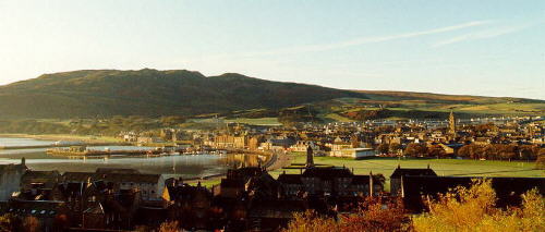
| Recent View of Campbeltown, Scotland |
1 Source: (51) page 449.
2 Source: (51) page 452.
3 Source: (51) page 450.
4 Source: (51) page 448.
5 Source: (27) page 135.
6 Source: (52) page 1...4.
7 Source: (27) page 36 .... 69
8 Source: (53) back cover.